Katrina impact on Internet2 backbone -- analysis
Via Boing Boing.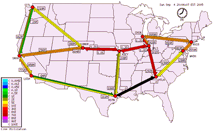
BB reader Mike Quinn in Austin says:
TheAbilene [Internet2] backbone between Houston and Atlanta is down since Katrina...
This live internet traffic map, hosted by Indiana University, is a dynamically generated image showing network usage data for the current point in time: Link.
Note the *black* arrow betw. HSTN and ATLA indicating zero traffic. All the east coast - west coast internet traffic now primarily travels on the Kansas City (KSCY) to Indianapolis (IPLS) backbone which is shown in *red* indicating high traffic levels...This link explains the features of the maps produced by the Animated Traffic Map system: Link
The diagrammatic map of the internet backbone shows a straight line route between Houston and Atlanta, but I'm pretty certain that the backbone actually travels along IH-10 (or IH-12) which passes through (just north of) New Orleans...
Map of US Interstate HWY System: Link
At Mobile, AL the backbone probably leaves the IH-10 right-of-way for the IH-69 R.O.W. to Atlanta.
The graphs at this link show the lack of traffic in and out of the Backbone circuit to Atlanta from Houston: Link Scroll down to see Daily, Weekly, Monthly, and yearly traffic.
Note that since the backbone is down betw. Atlanta and Houston, the traffic that would continue on to Los Angeles is much reduced: Link
More explanation of all this: Link
posted by Fergie @ 9/04/2005 06:47:00 PM
![]()
![]()


0 Comments:
Post a Comment
<< Home